Louisburg Square, ca. 1870-1900
Unknown
1870-1900
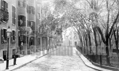
- Elevated-view south-southeast of Louisburg Square, located between Pinckney Street to the north-northwest and Mt. Vernon Street to the south-southeast. Houses lining the east side of Louisburg Square are visible in the left-half of the photograph. Houses lining the south-southeast side of Mt. Vernon Street are visible in the background of the photograph. A man, a boy and a woman stand on the ... read morestreet light-lined sidewalk on the east side of Louisburg Square. A woman is visible in the first-level window of 17 Louisburg Square. The park located in the center of Louisburg Square is included along the right side of the photograph. Development plan for Louisburg Square designed by Stephen P. Fuller, 1826; houses located at Louisburg Square built, 1834-48 4 1/2 x 7 5/8, 4 3/4 x 7 3/4 overall Albumen printsread less
- ID:
- k3569f061
- Component ID:
- tufts:TBS.VW0001.000858
- To Cite:
- TARC Citation Guide EndNote
- Usage:
- Detailed Rights
To request a high-resolution image, choose Add to List.
